
Sets your boundaries within limits


geographic
information
system
For those projects where a high level of detail is necessary for planning purposes, we provide a variety of efficient land mapping and GIS skills and technology. We assist clients with site assessment and pre-closing due diligence by compiling base maps that can be based on online GIS & zoning data, or mapping grade on-site location of features such as jurisdictional lines. This ensures there are no surprises in the planning process.
GIS SPECIALIST DIVISION
ERM Geomatics
Enhanced Reference Map
It shows important physical (natural and man–made) features in an area. Their main purpose is to summarize the landscape to aid discovery of locations. Commonly highlights places of interest that are easy to understand.

ERM Geomatics
River Soil Feasibility Study
Riverbank erosion is the removal of material from the banks of rivers when flowing water forces exceed bank resisting forces by the soil and vegetation. Rapidly changing river systems can impact people, property and infrastructures.


RSEA Feasibility study investigates bank erosion and accretion of a river, through temporal data.

ERM Geomatics
Base Map
A base map is a layer with geographic information that serves as a background. A base map provides context for additional layers that are overlaid on top of the base map. Base maps usually provide location references for features that do not change often like boundaries, rivers, lakes, roads, and highways.
ERM Geomatics
SAPA is an instrument issued to private persons and groups that allows them to make productive use of a protected area identified under Republic Act No. 7586, or the National Integrated Protected Areas System Act of 1992.

ERM Geomatics
Digital Elevation Model
Digital Surface Model
Digital Terrain Model
These are commonly implemented geospatial features generated with UAV mapping systems. Each data product delivers different elevation values as each model uses different methodologies.
ERM Geomatics
Grid Staking
Grid Staking is used for planned improvements for buildings and then taking note all of them on the site where the building is located, known as the construction staking process. It has a vital role to help an organization to jump from the blueprints to the actual work.


ERM Geomatics
Topographic Map
A topographic map is characterized by large-scale detail and quantitative representation of relief features, usually using contour lines, but historically using a variety of methods.
The following features are commonly shown,
-
Elevation Contours
-
Benchmark
-
Lot Boundary
-
Road Network
-
Excavation or Backfill
ERM Geomatics
Exact-As-Built (EAB)
It detects deviations: Using E-A-B regularly during construction allows you to keep track of whether construction is being carried out in accordance with the plans, and to quickly detect any deviations in time to make adjustments. This saves both time and money. And it ensures that your construction projects are profitable.


ERM Geomatics
A Height Evaluation Application shall be first secured from the Civil Aviation Authority of the Philippines (CAAP) before a building permit may be issued for the construction of buildings/structures located
-
Within 4-kilometer radius of the runway ends of an aerodrome regardless of height;
-
From 4-kilometer to 24-kilometer radius of the runway ends of an aerodrome where turbo-jet aircraft operate and exceeding 45.00 meters in height above the elevation of the runway; and
-
From 4-kilometer to 10-kilometer radius of the runway ends of an aerodrome where no turbo-jet aircraft operate and exceeding 45.00 meters in height above the elevation of the runway.
ERM Geomatics
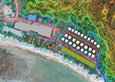
A master plan is a strategic document for the development of an area. It is a long-term vision for the future development of a place, including the goals and objectives of the community. A master plan typically includes land-use policies, zoning regulations, demographic projections, and budgetary forecasts. It may also have environmental protection, social services, public works projects, and public policies.
This is the service wherein it is shown the intended uses for the land into the future for as far as you want to take the project. Then, the map shall depict the future plans to help you and others understand how the project will logically and sequentially develop over the years.


ERM Geomatics
Mineral exploration proceeds step by step taking into account aerial photographs, satellite imagery, geological maps, geophysical maps, and geochemical maps to delineate areas of interest. Data generated by these techniques are stored in a thematic and textual database using suitable software.
Various techniques of combining and compressing these data have developed over the years, where computers play an important part. These data can be utilized for 2D or 3D modeling or for data mining. The data can be selectively combined to obtain information for likely locating of coal deposits.
